Thorpe St Peter
Coordinates: 53°07′22″N 0°12′58″E / 53.1228150°N 0.2162303°E
| Thorpe St Peter | |
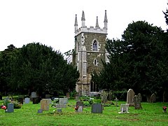
 St Peters church, Thorpe St Peter | |
| | |
| Population | 349 (2001) |
|---|---|
| OS grid reference | TF484606 |
| District | East Lindsey |
| Shire county | Lincolnshire |
| Region | East Midlands |
| Country | England |
| Sovereign state | United Kingdom |
| Postcode district | PE24 4 |
| Police | Lincolnshire |
| Fire | Lincolnshire |
| Ambulance | East Midlands |
| EU Parliament | East Midlands |
| UK Parliament | Boston and Skegness |
| List of places: UK • England • Lincolnshire | |
Thorpe St Peter is a village and civil parish in the East Lindsey district of Lincolnshire, England, about 1 mile (1.6 km) north west of the town of Wainfleet.
Thorpe was mentioned in Domesday Book of 1086 when it was listed as having 33 households, two mills and a church.
The parish church, dedicated to Saint Peter is a grade I listed building dating from 1200 with later additions and alterations, and restored in the 19th century. It is built of greenstone and limestone. The west tower dates from the mid-14th century, and there is an early 13th century font.
Thorpe Culvert railway station was opened here in 1873.
References
Retrieved from : http://en.wikipedia.org/w/index.php?title=Thorpe_St_Peter&oldid=462783259
No comments:
Post a Comment